 ar
ar bg
bg hr
hr cs
cs da
da nl
nl fi
fi fr
fr de
de el
el hi
hi it
it ko
ko no
no pl
pl pt
pt ro
ro ru
ru es
es sv
sv tl
tl iw
iw id
id lv
lv lt
lt sr
sr sk
sk sl
sl uk
uk vi
vi et
et hu
hu th
th tr
tr fa
fa ms
ms hy
hy ka
ka ur
ur bn
bn mn
mn ta
ta kk
kk uz
uz ku
ku
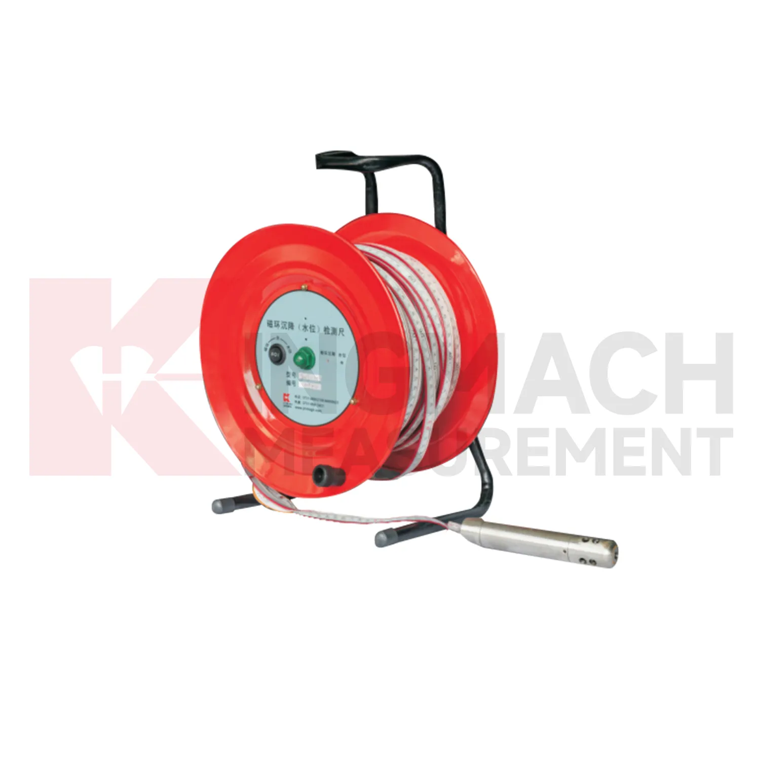
Magnetic Ring Settlement Water Level Gauge
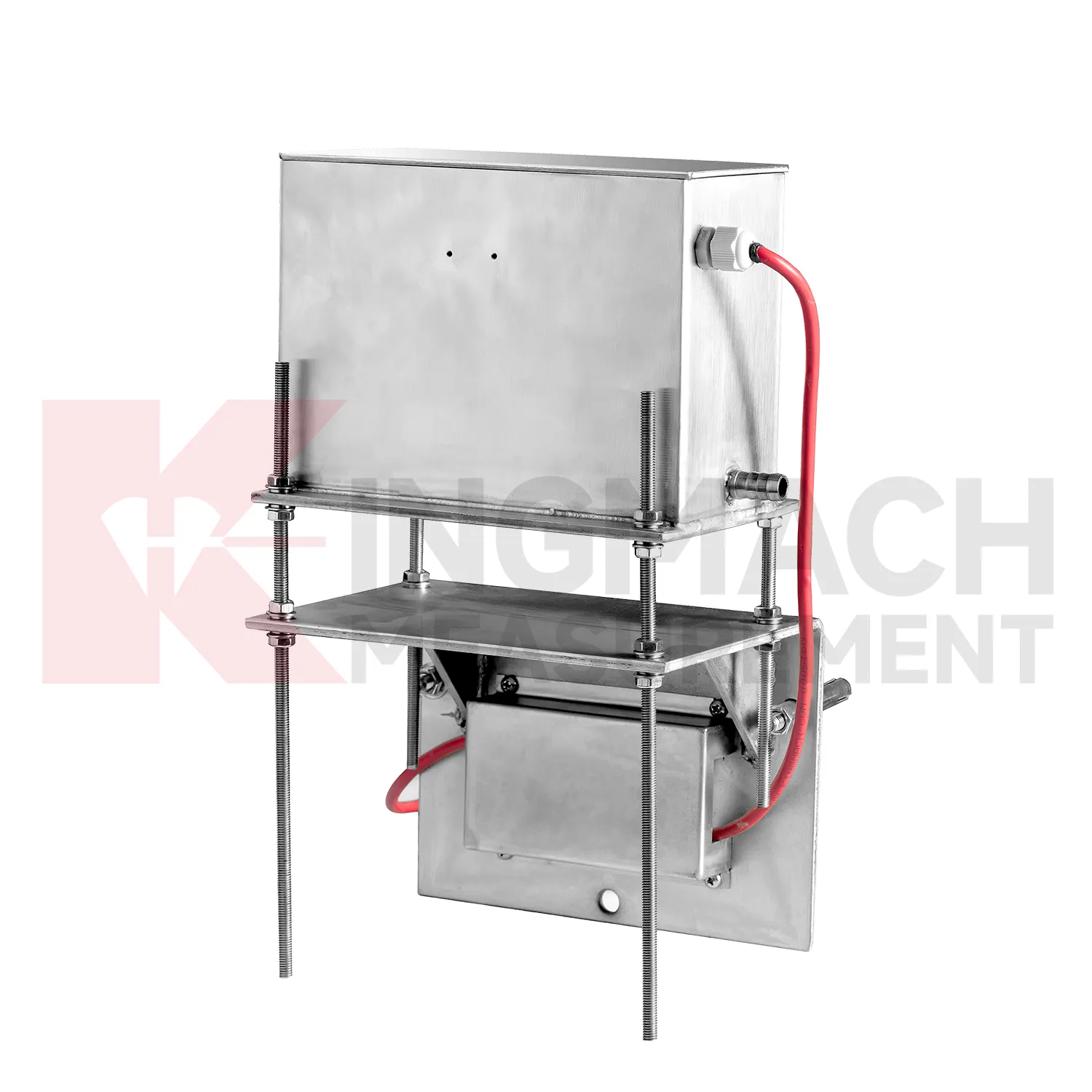
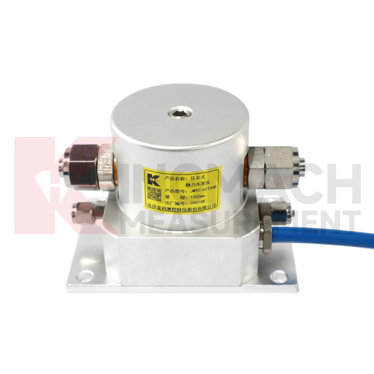
Kingmach Magnetic Ring Settlement Water Level Gauge include the JMDL-62XXADT inductive frequency-modulated hydrostatic level sensor for projects that need a hydrostatic reference network rather than isolated manual checks. The instrument is arranged with connecting tubes, so each measuring location works against a shared liquid level and a stable reference point. Listed ranges are 50 mm, 100 mm, and 200 mm, with 0.01 mm resolution, 0.5%FS accuracy, RS485 output, DC 9V to 24V supply, power consumption below 0.5W, and an operating temperature from -30 degrees Celsius to +80 degrees Celsius. It is applied in dam deformation observation, bridge deflection, slope stability, building settlement, and high-speed rail foundation monitoring. A good project layout starts with the reference benchmark, tube slope, exhaust position, cabinet height, cable route, and channel address. During commissioning, the crew should remove trapped air, confirm fluid continuity, record the initial level, and compare every channel under the same temperature condition. The data cabinet can then collect each channel by address and preserve a clear relation between tube branch, instrument serial number, and drawing location. This makes later data easier to judge because a curve change can be traced back to a named measuring point, a known hydraulic path, and a documented baseline.
Application of Magnetic Ring Settlement Water Level Gauge
In road and railway subgrade work, Magnetic Ring Settlement Water Level Gauge help track how fill, soft ground, and pile-net foundations behave after each construction stage. The risk is not only final settlement; engineers also need to know whether movement slows after compaction, continues after traffic loading, or restarts after rainfall. Kingmach JMDL-47XXAT can measure in-situ subgrade settlement and embankment heave with 100 mm, 200 mm, 300 mm, and 400 mm ranges. For longer pavement profiles, JMYC-62XXAD wide-range differential pressure hydrostatic sensors can compare several points against a reference, with 500 mm to 4000 mm ranges and 0.1 mm resolution. A practical subgrade monitoring plan records fill height, compaction stage, traffic opening date, groundwater condition, and nearby deformation readings. This helps maintenance teams decide whether the roadbed is consolidating normally or needs inspection before track or pavement defects appear. The monitoring team should keep point location, reference condition, construction timing, groundwater or water level notes, and nearby sensor behavior in one review file so the settlement curve can be interpreted without guesswork during later maintenance. The monitoring team should keep point location, reference condition, construction timing, groundwater or water level notes, and nearby sensor behavior in one review file so the settlement curve can be interpreted without guesswork during later maintenance.
The future of Magnetic Ring Settlement Water Level Gauge
The future of Magnetic Ring Settlement Water Level Gauge will also depend on better installation kits. Many settlement errors begin with field details: a tube is kinked, a plate is disturbed during compaction, a ring depth is recorded poorly, a cable exits at the wrong place, or a reference point is not protected. Future products can reduce these problems with clearer connectors, pre-labeled cables, stronger side-exit protection, better probe markings, and commissioning checklists. Kingmach JMDL-47XXAT already uses side-exit cable routing to avoid pavement compaction interference, and hydrostatic systems rely on clean tube installation. Better installation accessories will make the first baseline more trustworthy. In settlement monitoring, a clean start is often more useful than a later attempt to correct a poor record. The practical goal is to keep settlement data understandable after the original installation crew has left, so owners can compare old and new readings without reconstructing the field history from memory. The same record should remain readable for designers, contractors, owners, and maintenance teams, because settlement monitoring often continues long after the first construction report is finished.
Care & Maintenance of Magnetic Ring Settlement Water Level Gauge
Hydrostatic Magnetic Ring Settlement Water Level Gauge need regular checks of the liquid path. For systems using JMDL-62XXADT, JMQJ-62XXADT, or JMYC-62XXAD, inspect water pipes, connectors, sensor elevation, reference point, cabinet wiring, and tube protection. Kinks, leakage, air pockets, freezing risk, or construction damage can change the apparent settlement curve. Check whether readings change after pipe work, cabinet maintenance, or nearby excavation. For outdoor systems, protect tubes from vehicle traffic, sharp edges, workers, and animal damage. When a reading shifts suddenly, confirm the reference sensor and water path before treating the value as structural movement. Hydrostatic systems can be very useful, but they depend on a clean, continuous, well-documented connection between points. The record should include who inspected the point, what changed on site, and whether nearby instruments showed the same trend, so the maintenance team can separate sensor trouble from real settlement. The record should include who inspected the point, what changed on site, and whether nearby instruments showed the same trend, so the maintenance team can separate sensor trouble from real settlement.
Kingmach Magnetic Ring Settlement Water Level Gauge
Magnetic Ring Settlement Water Level Gauge are used when vertical movement must be measured before it becomes visible as cracks, uneven pavement, rail irregularity, or structural distress. Kingmach settlement products cover embedded single-point measurement, hydrostatic leveling, wide-range differential pressure monitoring, magnetic ring settlement and water level reading, and micro range deflection monitoring. On a roadbed, the reading may show whether filling and compaction are stabilizing. On a bridge, it may show deflection relative to a reference point. In a foundation pit, it may show base uplift after excavation or dewatering. The key is to treat settlement as a time-based record, not a one-time survey value. Each point should carry its model, range, reference point, baseline, installation depth, and acquisition channel so later engineers can understand what moved, when it moved, and why the value matters. During review, the team should compare the value with nearby points, construction timing, water condition, and inspection notes before deciding whether the movement is acceptable.
FAQ
Q: What is JMCJ-1003/1005 used for?
A: It is used to measure layered underground settlement and groundwater level in foundations, subgrades, foundation pits, embankments, and underground structures.
Q: How does magnetic ring settlement reading work?
A: Magnetic rings are placed underground; when the probe senses a ring, audible and visual alerts help the operator read depth from the steel tape at the borehole.
Q: How is water level detected?
A: The water level component works by water conductivity and alerts when the probe contacts water.
Q: What accuracy is listed?
A: The listed measurement accuracy is plus or minus 1 mm.
Q: What field records are needed?
A: Keep borehole number, magnetic ring depth, previous reading, current reading, groundwater level, and operator notes together.
Reviews
Daniel Brown
Excellent environmental monitoring sensors. The data is consistent, and the system integrates smoothly with our existing setup.
David Wilson
We purchased displacement transducers and settlement sensors, and the quality exceeded our expectations. Easy installation and reliable performance.
Latest Inquiries
To protect the privacy of our buyers, only public service email domains like Gmail, Yahoo, and MSN will be displayed. Additionally, only a limited portion of the inquiry content will be shown.
Evelyn***@gmail.comSouth Africa
Hi, we are a contractor working on tunnel construction and need settlement sensors and displacement ...
Amelia***@gmail.comSingapore
Hello, I am looking for visualization software for monitoring system data analysis. Please let me kn...
Related product categories
- Micro Range Hydrostatic Level Sensor
- Single-point Settlement Meter
- Optical Deflection Monitor
- Inclinometer-based Hydrostatic Leveling System
- Settlement Monitoring Rod
- Hydrostatic Leveling System
- Photoelectric Deflectometer
- gnss settlement sensors
- settlement sensor
- settlement sensors
- rod settlement gauge
- settlement gauge